Fisheries Offshore Surveys
Marine Radar Data Analysis
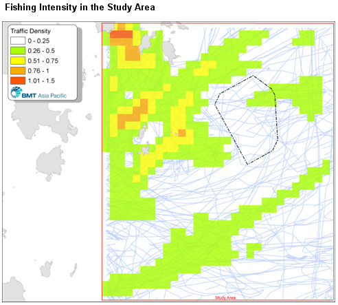
The below figure illustrates the distribution of sampled fishing activity between June and early July 2007 during the fishing
moratorium in the South China Sea. It is evident that most fishing activity is limited to inshore waters and those around the
Ninepin Islands. The proposed wind farm site is not within the main fishing area in Eastern Waters.
Boat-Based Observations
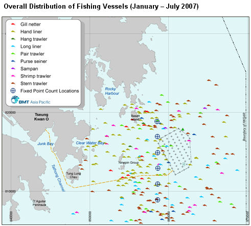
The below figure displays all fishing vessels recorded during boat-based observations between January and July 2007.
In order to facilitate data analysis vessels were broadly divided into two categories: trawlers (>15m) and non-trawlers (<15m).
Trawlers include stern, pair, hang and shrimp trawlers, while non-trawling vessels comprise purse seiners, gill-netters, long
liners, hand liners and sampans.
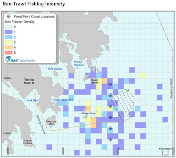
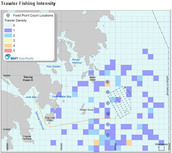
It is apparent that the densities in these figures corresponds strongly with the findings of the Marine Radar Data Analysis and
with data from the Port Survey studies. The figures indicate that trawling is concentrated in southern waters, with some activity
in waters to the northwest and east of the wind farm, but little within the proposed wind farm area. Non-trawling activity is
focussed around more sheltered islands, notably west of the Ninepin Islands and Basalt Island, although there were also
observations of these small vessels offshore when sea state was very calm (i.e., Beaufort scale ≤ 2). The activity of small
vessels near the proposed wind farm appears to be very low.
Marine Radar Data Analysis
The below figure illustrates the distribution of sampled fishing activity between June and early July 2007 during the fishing
moratorium in the South China Sea. It is evident that most fishing activity is limited to inshore waters and those around the
Ninepin Islands. The proposed wind farm site is not within the main fishing area in Eastern Waters.
Boat-Based Observations
The below figure displays all fishing vessels recorded during boat-based observations between January and July 2007.
In order to facilitate data analysis vessels were broadly divided into two categories: trawlers (>15m) and non-trawlers (<15m).
Trawlers include stern, pair, hang and shrimp trawlers, while non-trawling vessels comprise purse seiners, gill-netters, long
liners, hand liners and sampans.
It is apparent that the densities in these figures corresponds strongly with the findings of the Marine Radar Data Analysis and
with data from the Port Survey studies. The figures indicate that trawling is concentrated in southern waters, with some activity
in waters to the northwest and east of the wind farm, but little within the proposed wind farm area. Non-trawling activity is
focussed around more sheltered islands, notably west of the Ninepin Islands and Basalt Island, although there were also
observations of these small vessels offshore when sea state was very calm (i.e., Beaufort scale ≤ 2). The activity of small
vessels near the proposed wind farm appears to be very low.

| |
| |
| |
| |
| |
| |
| |
| |
| |
| |
| |
| |
| |
| | | | |
| | |