Fisheries Operation Impact Assessment
Hazard to Fishing Vessels
A Marine Navigation Safety Risk Assessment (MNSRA) has been conducted to assess impact of the wind farm on the
existing and future marine traffic profile in south-eastern waters
The MNSRA concluded that restriction is required to manage “created behaviours” anticipated within the wind farm area.
In order to manage these risks it is proposed that the wind farm area is designated as a controlled waterspace through
the development of byelaws or similar legal instruments. Waterborne access would be restricted to vessels that have
applied for permits. The following vessel restrictions are proposed:
Loss of Fishing Ground to Commercial Fishing Activities
Considering all fishing vessels will be excluded from the wind farm area for marine navigation safety reasons, a total of
<16 km2 of sea area will be permanently lost as a fishing ground.
However, the following characteristics of the proposed wind farm site discount its overall value to the local fishing industry:
While the wind farm components will only occupy less than 0.06 km2 of seabed, equivalent to ~0.4% of the entire wind
farm footprint, the remaining 99.6% will remain as open waters. Accordingly, against the low baseline fisheries
productivity and hence value of the wind farm area, a low fisheries impact may be anticipated from the exclusion of fishing
vessels from these waters.
Given the nature of the Project and proposed management of the study area, the Project Area could potentially be
available for the management and enhancement of fisheries resources.
Fisheries Enhancement Potential
Danish Offshore Wind Farms
The Danish Energy Authority conducted an environmental monitoring programme between 2000 and 2006 for the two
Danish offshore wind farms. This study provides qualitatively evaluation on the actual environmental performance at the
wind farm sites during the operation phase. The key findings of this monitoring study related to fishery resources are
summarised as follows:
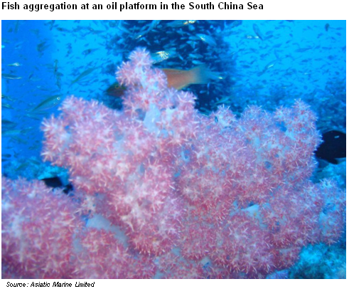
Dive Observations at Offshore Oil and Gas Platforms in the South China Sea
The established marine fouling and coral communities on the surface of the oil and gas platforms in the South China
Sea support rich pelagic species.
Predator fish species such as barracuda, tuna and snappers have been observed in the area with some of the fish size
reach as long as 1.5m. Other reef fishes, lobsters and moray eels are also residents in these ecosystems. The fish
species richness at the platform sites is unique as number of fish becomes scarce in waters 10m to 15m away from the
platforms.
Hazard to Fishing Vessels
A Marine Navigation Safety Risk Assessment (MNSRA) has been conducted to assess impact of the wind farm on the
existing and future marine traffic profile in south-eastern waters
The MNSRA concluded that restriction is required to manage “created behaviours” anticipated within the wind farm area.
In order to manage these risks it is proposed that the wind farm area is designated as a controlled waterspace through
the development of byelaws or similar legal instruments. Waterborne access would be restricted to vessels that have
applied for permits. The following vessel restrictions are proposed:
- Marine vessel management with a designated Marine Restricted Area;
- Trawling activity would be prohibited;
- Permitted marine vessels would include all Government vessels and wind farm maintenance vessels, and may
be extended to include dive boats, tourist launches, hand-line fishing vessels, etc.; and - Permitted marine vessels are anticipated to be required to carry Automated Identification System (AIS)
transmitters to monitor and safeguard their operations, and ensure they are seaworthy for offshore conditions.
Loss of Fishing Ground to Commercial Fishing Activities
Considering all fishing vessels will be excluded from the wind farm area for marine navigation safety reasons, a total of
<16 km2 of sea area will be permanently lost as a fishing ground.
However, the following characteristics of the proposed wind farm site discount its overall value to the local fishing industry:
- Uniform and exposed muddy seabed with no habitat diversity is unattractive to fish as a shelter or feeding area.
- Very limited to no spawning activity in the area means the site is of low importance as a potential spawning /
nursery ground for replenishing depleted fisheries. - Low productivity and commercial value in waters with a very low catch per unit effort.
- Rough sea conditions for much of the year make it unsafe for vessels to operate in this area.
- Remoteness of the site coupled with low catch per unit effort decreases its commercial value due to the high fuel
cost.
While the wind farm components will only occupy less than 0.06 km2 of seabed, equivalent to ~0.4% of the entire wind
farm footprint, the remaining 99.6% will remain as open waters. Accordingly, against the low baseline fisheries
productivity and hence value of the wind farm area, a low fisheries impact may be anticipated from the exclusion of fishing
vessels from these waters.
Given the nature of the Project and proposed management of the study area, the Project Area could potentially be
available for the management and enhancement of fisheries resources.
Fisheries Enhancement Potential
Danish Offshore Wind Farms
The Danish Energy Authority conducted an environmental monitoring programme between 2000 and 2006 for the two
Danish offshore wind farms. This study provides qualitatively evaluation on the actual environmental performance at the
wind farm sites during the operation phase. The key findings of this monitoring study related to fishery resources are
summarised as follows:
- Presence of wind farm structures: The overall habitat heterogeneity and species richness has increased as a
result of introducing artificial structures in the previously homogenous sandy seabed, permitting colonisation by
an epibenthic community. - Exclusion of fishing activity in the wind farms: The absence of fishing activity, particularly trawling, is deemed key to
boosting the abundance and diversity of the benthic ecosystem. - Impacts on fish communities as a result of operation of the wind farms: Statistically, no adverse impacts on fish
population have been identified. The study has forecasted that the potential for enhancing fish supply cannot be
overlooked once the benthic communities become fully established in the wind farm areas.
Dive Observations at Offshore Oil and Gas Platforms in the South China Sea
The established marine fouling and coral communities on the surface of the oil and gas platforms in the South China
Sea support rich pelagic species.
Predator fish species such as barracuda, tuna and snappers have been observed in the area with some of the fish size
reach as long as 1.5m. Other reef fishes, lobsters and moray eels are also residents in these ecosystems. The fish
species richness at the platform sites is unique as number of fish becomes scarce in waters 10m to 15m away from the
platforms.

| |
| |
| |
| |
| |
| |
| |
| |
| |
| |
| |
| |
| |
| | | | |