Heritage Survey
In accordance with marine archaeological investigation (MAI) guidelines, a marine geophysical
survey was conducted in August 2006 with the aims of:
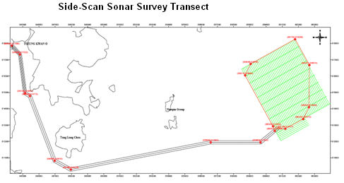
The geophysical survey involved the use of side-scan sonar to collect approximately 270-line
kilometres of data, comprising approximately:
The survey lines were generally arranged at 100-metre spacing, except for the inshore section at
Tseung Kwan O where a spacing of 50 metres was appropriate given the shallow water depth.
Overall, survey lines were arranged to ensure 100 percent overlap with adjacent transects, and also
allowing some flexibility for potential changes in cable / turbine positioning.
In accordance with marine archaeological investigation (MAI) guidelines, a marine geophysical
survey was conducted in August 2006 with the aims of:
- Providing exact definition of objects of greatest archaeological potential;
- Assessing the depth and nature of the seabed sediments to define which areas consist of
suitable material to bury and preserve archaeological material; and - Examining geophysical data to map anomalies on the seabed that may be archaeological
material.
The geophysical survey involved the use of side-scan sonar to collect approximately 270-line
kilometres of data, comprising approximately:
- 73 km along the cable route corridor; and
- 197 km covering the entire Windfarm site.
The survey lines were generally arranged at 100-metre spacing, except for the inshore section at
Tseung Kwan O where a spacing of 50 metres was appropriate given the shallow water depth.
Overall, survey lines were arranged to ensure 100 percent overlap with adjacent transects, and also
allowing some flexibility for potential changes in cable / turbine positioning.

| |
| |
| |
| |
| |
| |
| |
| |
| |
| |
| |
| |
| |
| | | | |
| | |