Heritage Mitigation & Monitoring
Mitigation of Potential Impacts on Target A1
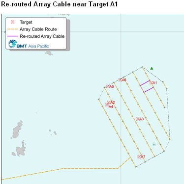
Based on the current tentative array cable alignment, Target A1 may be exposed to an adverse impact during
jetting. Accordingly, it is proposed to re-route the array cable alignment to eliminate the potential impact. This is
displayed below.
Since additional penetrative investigation will be conducted during the detailed design studies stage, in case
other buried / masked objects are identified where construction is scheduled, avoidance shall be adopted as
the primary mitigation approach as far as practicable.
Provided that the recommended mitigation measures are fully implemented, the distance between all targets
and works areas shall exceed the 150m buffer zones and thus potential impact potential is considered to be
minor.
Best Practice Impact Avoidance Measures for all Targets
With the exception of Target A1 located on the proposed array cable route, the construction and operational
phase impact assessments have indicated that no adverse impacts are anticipated, i.e., impact significance
varies from ‘minor’ to ‘insignificant’.
As the development intention is to maintain the disturbance magnitude at the minimum level practicable, a
150m-diameter buffer zone shall be implemented around each identified target as a best practice measure to
ensure potential impacts can be avoided. Within these buffer zones there shall be no permanent works or
temporary anchoring of construction or maintenance vessels.
Environmental Monitoring & Audit
It is the full intention that the Project gives priority to impact avoidance through the sensitive location of turbines
and cables, rather than impact mitigation. To ensure the Project development does not result in any
unforeseen impacts on objects of marine archaeological potential, further marine geophysical comprising
seismic and magnetic surveys shall be conducted across the Study Area as the detailed engineering design
advances, and before any marine construction works commence.
Such further marine geophysical surveys shall be conducted to an appropriate specification prepared by a
qualified geophysicist and to the satisfaction of a qualified marine archaeologist. Upon completion of the
surveys, a Report shall be prepared by the qualified marine archaeologist for submission to AMO to include
inter alia, the findings of the further marine geophysical survey and a discussion on the need for dive surveys.
Should any additional targets of archaeological significance be identified during these surveys, potential
adverse impacts shall be mitigated via a strategy of avoidance.
It is also proposed the 150m buffer separation be implemented with the use of on-board GPS systems for
marine vessel positioning. The contractor shall be required to maintain such records during construction for
those works in the vicinity of the targets.
Mitigation of Potential Impacts on Target A1
Based on the current tentative array cable alignment, Target A1 may be exposed to an adverse impact during
jetting. Accordingly, it is proposed to re-route the array cable alignment to eliminate the potential impact. This is
displayed below.
Since additional penetrative investigation will be conducted during the detailed design studies stage, in case
other buried / masked objects are identified where construction is scheduled, avoidance shall be adopted as
the primary mitigation approach as far as practicable.
Provided that the recommended mitigation measures are fully implemented, the distance between all targets
and works areas shall exceed the 150m buffer zones and thus potential impact potential is considered to be
minor.
Best Practice Impact Avoidance Measures for all Targets
With the exception of Target A1 located on the proposed array cable route, the construction and operational
phase impact assessments have indicated that no adverse impacts are anticipated, i.e., impact significance
varies from ‘minor’ to ‘insignificant’.
As the development intention is to maintain the disturbance magnitude at the minimum level practicable, a
150m-diameter buffer zone shall be implemented around each identified target as a best practice measure to
ensure potential impacts can be avoided. Within these buffer zones there shall be no permanent works or
temporary anchoring of construction or maintenance vessels.
Environmental Monitoring & Audit
It is the full intention that the Project gives priority to impact avoidance through the sensitive location of turbines
and cables, rather than impact mitigation. To ensure the Project development does not result in any
unforeseen impacts on objects of marine archaeological potential, further marine geophysical comprising
seismic and magnetic surveys shall be conducted across the Study Area as the detailed engineering design
advances, and before any marine construction works commence.
Such further marine geophysical surveys shall be conducted to an appropriate specification prepared by a
qualified geophysicist and to the satisfaction of a qualified marine archaeologist. Upon completion of the
surveys, a Report shall be prepared by the qualified marine archaeologist for submission to AMO to include
inter alia, the findings of the further marine geophysical survey and a discussion on the need for dive surveys.
Should any additional targets of archaeological significance be identified during these surveys, potential
adverse impacts shall be mitigated via a strategy of avoidance.
It is also proposed the 150m buffer separation be implemented with the use of on-board GPS systems for
marine vessel positioning. The contractor shall be required to maintain such records during construction for
those works in the vicinity of the targets.

| |
| |
| |
| |
| |
| |
| |
| |
| |
| |
| |
| |
| |
| | | | |