Landscape and Visual Envelope
The Visual Envelope (or Zone of Visual Influence, ZVI) for the Project will be largely similar during
the Construction Phase and Operational phase, as there will be no especially tall temporary
machinery or structures associated with construction works.
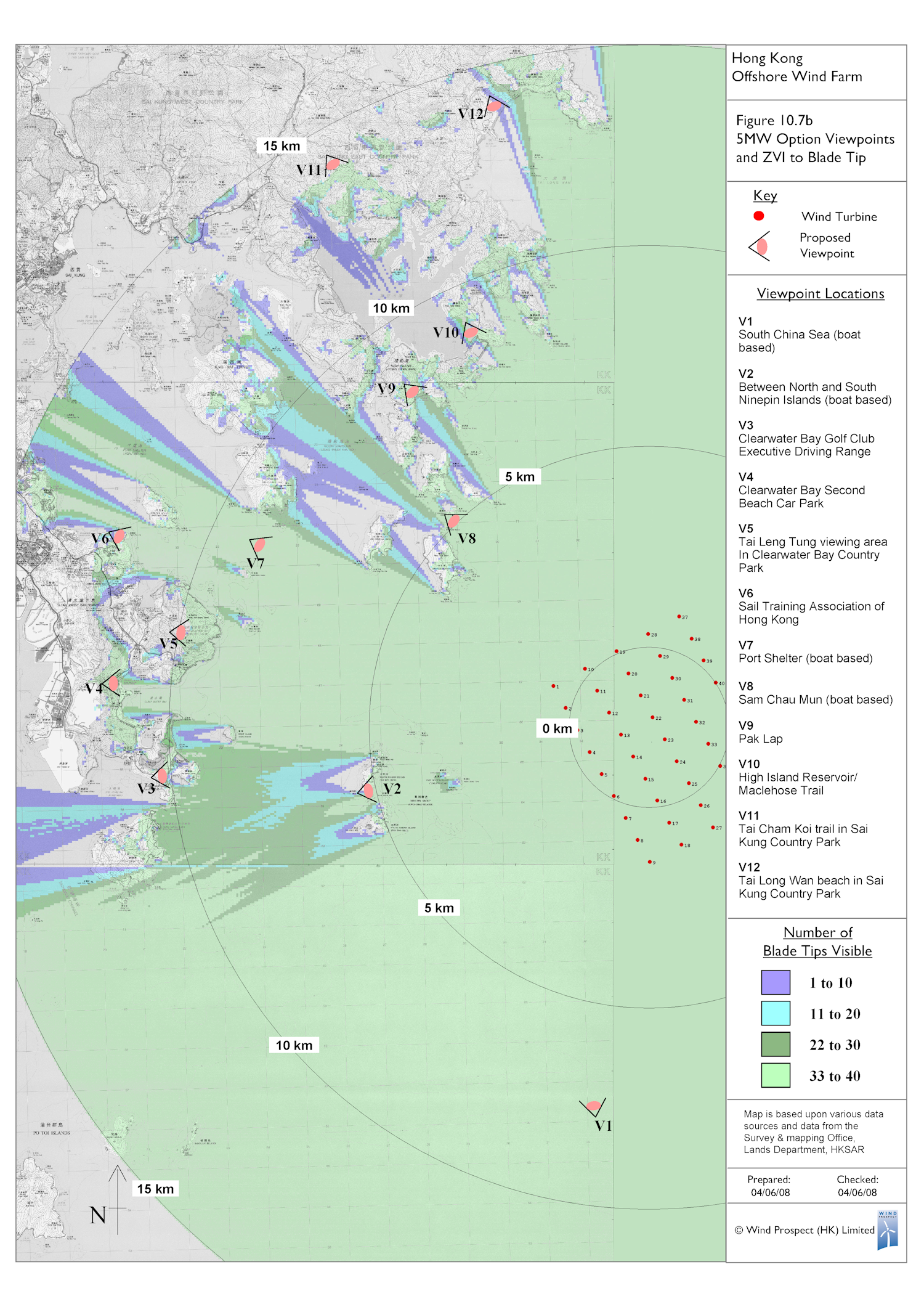
For the purposes of the Study, the Visual Envelope is divided into a Primary Visual Envelope and a
Secondary Visual Envelope. The Primary Visual Envelope is that area within 15km of the Project
from which it can be seen. Although in a small number of cases, there will be a direct line of sight
to the Project from areas beyond this distance, the effects of distance will mean that any visual
impacts are not significant.
Given the marine location of the Project, the Visual Envelope will be large, with intervening
landforms defining it only to the north-west, west and south west. The Primary Visual Envelope is
described below and is mapped in adjacent figures.
To the north and north-west, the Primary Visual Envelope covers the shore of the south-east New
Territories from Basalt Island, Bluff Island, Town Island and the mouth of the High Island Reservoir,
extending north to Tai Long Wan and the adjacent headland. This area includes small sections of
road running along the southern shore of the Reservoir and in foothills to the north. The Primary
Visual Envelope also includes the south east coast of Kau Sai Chau (and very small areas of the
golf course) and Jin Island. The Proposed Geological Park (Sai Kung Region) falls within this
portion of the Primary Visual Envelope.
To the west, the Primary Visual Envelope extends as far as the spit of land separating Inner Port
Shelter from Hebe Haven, as well as the mouth of Hebe Haven itself. Turbines will be visible along
part of the east of Clear Water Bay Peninsula, west to the High Junk Peak Trail and as far south as
the Clear Water Bay Country Club and the east coast of Tung Lung Chau.
To the south and southwest, the Primary Visual Envelope includes extensive areas of offshore
water as far as Waglan Island and Sung Kong Island.
Finally, to the south and east, the Primary Visual Envelope includes areas of offshore water as far
as the boundary of Hong Kong SAR territorial waters.
The Visual Envelope (or Zone of Visual Influence, ZVI) for the Project will be largely similar during
the Construction Phase and Operational phase, as there will be no especially tall temporary
machinery or structures associated with construction works.
For the purposes of the Study, the Visual Envelope is divided into a Primary Visual Envelope and a
Secondary Visual Envelope. The Primary Visual Envelope is that area within 15km of the Project
from which it can be seen. Although in a small number of cases, there will be a direct line of sight
to the Project from areas beyond this distance, the effects of distance will mean that any visual
impacts are not significant.
Given the marine location of the Project, the Visual Envelope will be large, with intervening
landforms defining it only to the north-west, west and south west. The Primary Visual Envelope is
described below and is mapped in adjacent figures.
To the north and north-west, the Primary Visual Envelope covers the shore of the south-east New
Territories from Basalt Island, Bluff Island, Town Island and the mouth of the High Island Reservoir,
extending north to Tai Long Wan and the adjacent headland. This area includes small sections of
road running along the southern shore of the Reservoir and in foothills to the north. The Primary
Visual Envelope also includes the south east coast of Kau Sai Chau (and very small areas of the
golf course) and Jin Island. The Proposed Geological Park (Sai Kung Region) falls within this
portion of the Primary Visual Envelope.
To the west, the Primary Visual Envelope extends as far as the spit of land separating Inner Port
Shelter from Hebe Haven, as well as the mouth of Hebe Haven itself. Turbines will be visible along
part of the east of Clear Water Bay Peninsula, west to the High Junk Peak Trail and as far south as
the Clear Water Bay Country Club and the east coast of Tung Lung Chau.
To the south and southwest, the Primary Visual Envelope includes extensive areas of offshore
water as far as Waglan Island and Sung Kong Island.
Finally, to the south and east, the Primary Visual Envelope includes areas of offshore water as far
as the boundary of Hong Kong SAR territorial waters.

| |
| |
| |
| |
| |
| |
| |
| |
| |
| |
| |
| |
| |
| | | | |

ZVI for 3MW layout (please click to
expand)
expand)
ZVI for 5MW layout (please click to
expand)
expand)
| | |