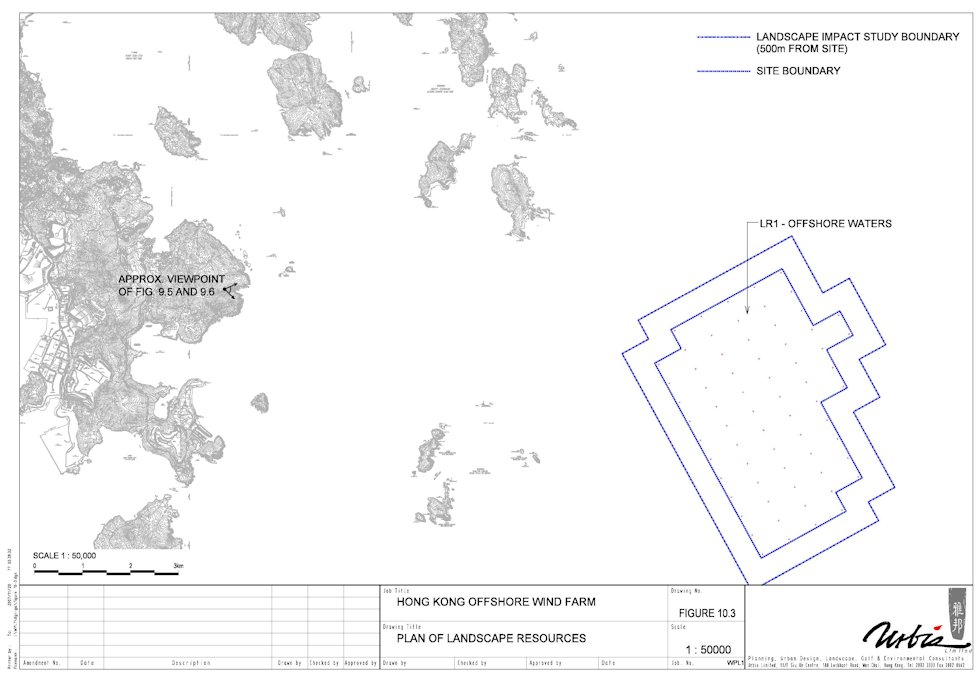
Landscape and Visual Baseline
Physical Landscape Resources
Being a marine site, the landscape resources that will be affected by the Project are limited to the
offshore waters themselves. There are no islands or landmasses within the Study Area.
The offshore waters that will be affected during the Construction Phase and Operational Phase,
together with its sensitivity to change, are described below. The locations of the offshore waters
are mapped in the adjacent figure. Photo-views illustrating them are provided aswell. For ease of
reference the landscape resource is given an identity number (LR1).
LR1 – Offshore Waters
This resource consists of an extensive body of offshore water lying off the coast of Hong Kong
extending as far as the boundary of Hong Kong Territorial Waters. Hong Kong has an abundance
of offshore water and given this abundance, it is a landscape resource of low sensitivity.
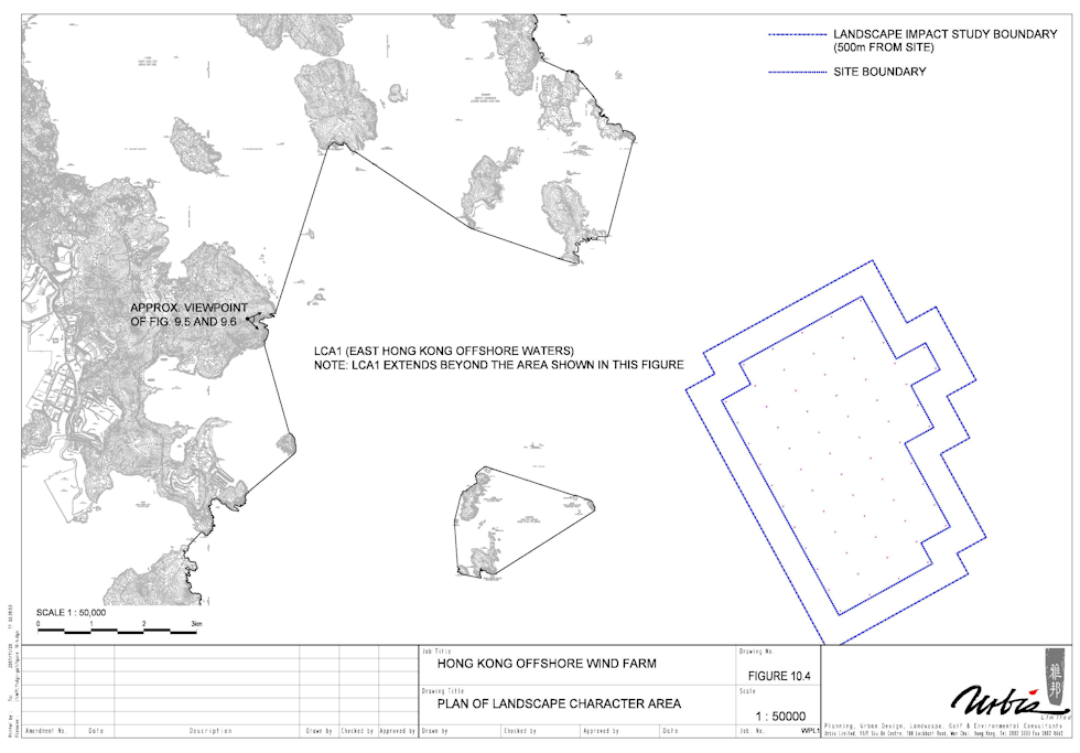
Landscape Character Area
One landscape character area (LCA) covers the entire Study Area. This was identified in Planning
Department’s Landscape Value Mapping Study (2005) and is described below. The location of the
character area is indicated in the adjacent figure. For ease of reference the Landscape Character
Area is given the identity number, LCA1.
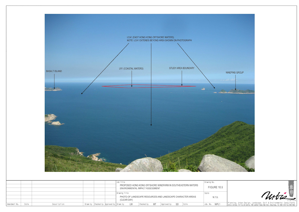
LCA1 – East Hong Kong Offshore Waters
This landscape comprises an extensive, homogenous area of offshore water off the east coast of
the New Territories of Hong Kong, between Mirs Bay in the north and the Po Toi Islands in the
south.
It consists predominantly of the water itself as well as a number of small rocky islands scattered
throughout them typically rising to no more than 50mPD. These include Cheung Tsui Chau; Conic
Island (Fan Tsang Chau); Po Pin Chau; Wong Nai Chau and Kong Tau Pai. Vegetation on these
islands comprises patches of scrub and grass. Apart from the waters and these scattered
islands, the landscape also includes occasional commercial and pleasure craft. This is a
landscape in which the skies and their quality are almost as important as other features, giving it
an expansive, open and ‘airy’ quality. It is also an almost uniform landscape of huge scale
elements, which has a character that is generally tranquil and which has a distinct sense of
remoteness and exposure.
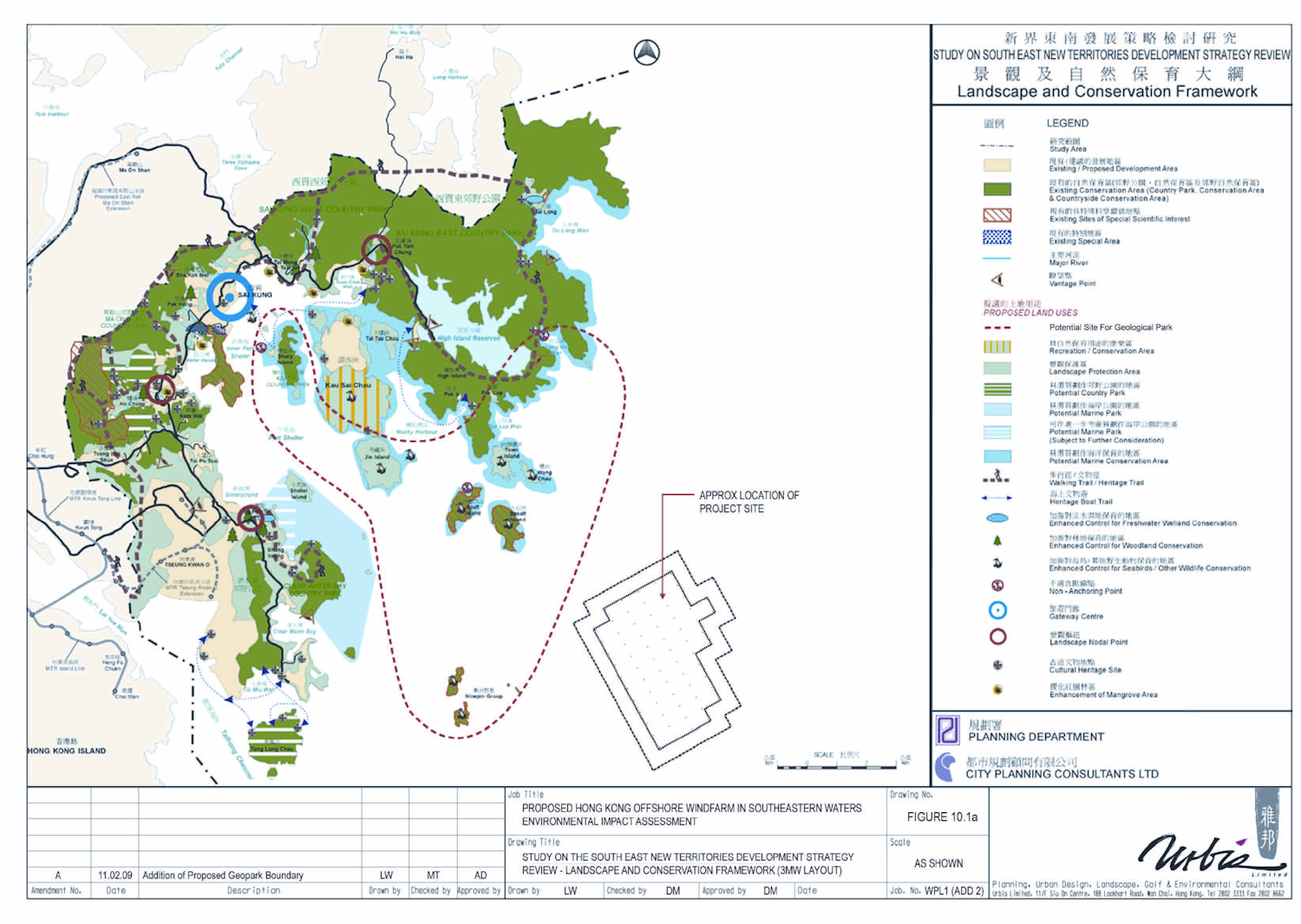
Islands within this LCA but beyond the limits of the study area include High Island, Tai Long Wan,
Sharp Island, Ninepin Group, Wang Chau, Basalt Island and Bluff Island, all of which feature rare
volcanic columns and are included in the Sai Kung portion of the Proposed Geological Park.
However, as these islands fall outside the study area for the Project there will be no additional
residual landscape impacts affecting the landscape character of the proposed Geological Park
This is a very extensive landscape and so changes to it are likely to be small in magnitude.
However, it is also a landscape, which by virtue of its openness and simplicity has a high
sensitivity to change.
Physical Landscape Resources
Being a marine site, the landscape resources that will be affected by the Project are limited to the
offshore waters themselves. There are no islands or landmasses within the Study Area.
The offshore waters that will be affected during the Construction Phase and Operational Phase,
together with its sensitivity to change, are described below. The locations of the offshore waters
are mapped in the adjacent figure. Photo-views illustrating them are provided aswell. For ease of
reference the landscape resource is given an identity number (LR1).
LR1 – Offshore Waters
This resource consists of an extensive body of offshore water lying off the coast of Hong Kong
extending as far as the boundary of Hong Kong Territorial Waters. Hong Kong has an abundance
of offshore water and given this abundance, it is a landscape resource of low sensitivity.
Landscape Character Area
One landscape character area (LCA) covers the entire Study Area. This was identified in Planning
Department’s Landscape Value Mapping Study (2005) and is described below. The location of the
character area is indicated in the adjacent figure. For ease of reference the Landscape Character
Area is given the identity number, LCA1.
LCA1 – East Hong Kong Offshore Waters
This landscape comprises an extensive, homogenous area of offshore water off the east coast of
the New Territories of Hong Kong, between Mirs Bay in the north and the Po Toi Islands in the
south.
It consists predominantly of the water itself as well as a number of small rocky islands scattered
throughout them typically rising to no more than 50mPD. These include Cheung Tsui Chau; Conic
Island (Fan Tsang Chau); Po Pin Chau; Wong Nai Chau and Kong Tau Pai. Vegetation on these
islands comprises patches of scrub and grass. Apart from the waters and these scattered
islands, the landscape also includes occasional commercial and pleasure craft. This is a
landscape in which the skies and their quality are almost as important as other features, giving it
an expansive, open and ‘airy’ quality. It is also an almost uniform landscape of huge scale
elements, which has a character that is generally tranquil and which has a distinct sense of
remoteness and exposure.
Islands within this LCA but beyond the limits of the study area include High Island, Tai Long Wan,
Sharp Island, Ninepin Group, Wang Chau, Basalt Island and Bluff Island, all of which feature rare
volcanic columns and are included in the Sai Kung portion of the Proposed Geological Park.
However, as these islands fall outside the study area for the Project there will be no additional
residual landscape impacts affecting the landscape character of the proposed Geological Park
This is a very extensive landscape and so changes to it are likely to be small in magnitude.
However, it is also a landscape, which by virtue of its openness and simplicity has a high
sensitivity to change.

| |
| |
| |
| |
| |
| |
| |
| |
| |
| |
| |
| |
| |
| | | | |
Landscape Character Plan
LCA1 (click to expand)
LCA1 (click to expand)

Landscape Character Plan
LR1 (click to expand)
LR1 (click to expand)
Photo of Landscape Character
Partial Cloud (click to expand)
Partial Cloud (click to expand)
No Cloud (click to expand)
Strategy (click to expand)
| | |